
In This Article
June 12th we leave for the Cabot Trail. Three days, two nights, one Indian Pursuit, and a lot of firsts happening all at once. This is our first real ride of 2026, Monique's first legitimate run as a passenger on the Pursuit, and our first time riding with a group of people we've never been on the road with before. That last part is both exciting and a little unnerving.
Here's everything we're doing to prepare — and everything you need to know if you're planning a similar trip.
Trip at a Glance
Cabot Trail on Two Wheels: Our First Big Ride of 2026
The Plan
The Cabot Trail is 298 km (186 miles) of pure riding. It winds around the northern tip of Cape Breton Island through the Cape Breton Highlands National Park — coastal cliffs, mountain switchbacks, ocean views that look fake. It consistently shows up on lists of the best motorcycle roads in the world, and it's right in our backyard.
We actually found this whole trip through a post in a local motorcycle Facebook group — someone put it out there, people responded, and suddenly we're riding with a crew we've never met in person. That's one of the things I genuinely love about the riding community. A Facebook post turns into a multi-day trip with a group of strangers who all share the same obsession.
Day 1 — June 12: Dieppe to Baddeck (~430 km)
The group is meeting at 9 AM in Amherst, Nova Scotia. For us that means leaving Dieppe early — Amherst is only about 60 km from home, so it's an easy start to the morning — no need to leave at the crack of dawn. We can be at the meetup point comfortably with a relaxed departure around 7:30–8 AM. Amherst is the perfect rally point; it sits right at the NS border and is a natural gathering spot for anyone coming from New Brunswick.
From Amherst the group rides together the remaining ~354 km to Baddeck via the Trans-Canada through Antigonish and then onto Cape Breton Island over the Canso Causeway. It's not the most exciting stretch of road in the world, but it's a solid warm-up ride and a good opportunity to figure out how the group moves together before we hit the real stuff the next day. Figure about 2.5–3 hours of riding to Baddeck from Amherst with a fuel stop along the way.
Day 2 — June 13: The Cabot Trail Loop (~298 km)
The full trail day. 298 km of the best riding in Canada. We'll base out of Baddeck and return to the motel at the end — no bags to carry, no hotel change, just a full day on the road. Plan for 6–8 hours including stops, meals, and time at the lookouts. This isn't a day to rush.
The standard approach is to ride clockwise — departing Baddeck through Cheticamp and hitting the dramatic highlands section (French Mountain, MacKenzie Mountain, North Mountain) before swinging back down the eastern coast through Ingonish. Counterclockwise puts you on the cliff-side ocean views in the morning, which some riders prefer. With a group, we'll follow whatever direction is decided together — but clockwise is my instinct for the light and scenery payoff.
Day 3 — June 14: Baddeck Home (~415 km)
One full day dedicated to getting home. That's the deal with this trip — one day to get there, one day on the trail, one day back. Clean and simple. The return is roughly 415 km, same route in reverse through the Canso Causeway, Antigonish, and across the border into New Brunswick. Aim to leave Baddeck by 9 AM and you're home comfortably before dark. After a full day on the Cabot Trail the day before, the highway miles back are almost meditative.
Monique's First Real Passenger Ride
This is the part I'm thinking about the most. Monique has been on the Pursuit before for short hops, but nothing like a full day on the Cabot Trail. 298 km of mountain roads, switchbacks, and elevation changes is a completely different experience than a 20-minute cruise.
What We're Doing to Prepare
- Communication: We're running the NYTalk N8 Mesh Intercom — I just reviewed it and it's a legit budget alternative to Cardo and Sena. Non-negotiable on a trip like this — she needs to be able to tell me if she needs a break, if something feels off, or if there's something worth stopping for.
- Body position briefing: Passenger body position matters on a touring bike. Lean with the rider, not against the lean. Feet on the pegs at all times — even at stops until told otherwise. No sudden movement. Hands on my hips or the grab rail, not on my shoulders.
- Comfort gear: The Pursuit has a proper passenger seat and backrest, which helps enormously on long days. She'll be in full gear — jacket, gloves, helmet — no shortcuts on safety because it's her "first big one."
- Realistic stop schedule: We're planning stops roughly every 60–90 minutes. The trail has natural pull-offs at the major lookouts — that works in our favour. A passenger who's uncomfortable is a distraction. We're not racing anyone.
- Pre-ride talk: The night before, we'll walk through the day — roughly where we're stopping, what the road is like, what to expect on the mountain sections. No surprises is the goal.
Riding with Strangers: The Group Dynamic
This is genuinely the wildest variable of the trip. Riding with a group of people you've never ridden with means you have no idea about their skill level, their riding style, their pace, or how they handle decisions on the road. That can go great — or it can create tension and safety issues.
What I'm Doing to Manage It
- Riders' meeting before we leave: Get everyone in one spot before hitting the road. Establish the pace, the stop points, what happens if someone gets separated, and hand signals everyone agrees on.
- Staggered formation: Standard group riding formation — odd-numbered riders on the left third of the lane, even on the right, one second gap between you and the rider directly ahead, two seconds to the rider in the same lane position. Never ride side by side.
- Fastest rider leads, slowest sets the pace: A good lead rider picks a pace the whole group can handle. If someone is clearly struggling, the group adjusts — not the struggling rider. The goal is everyone arrives safely, not a time trial.
- Know your exit: On the Cabot Trail specifically, the speeds and road conditions vary wildly. If the group is pushing a pace that's uncomfortable with Monique on the back, we'll drop off and ride our own ride. We know where the stops are. There's no shame in it.
- Don't ride beyond your ability for social pressure: This is the most important one. More accidents happen in group rides because someone tries to keep up with faster riders than they're comfortable with. The Pursuit two-up on a mountain road isn't the place to prove anything.
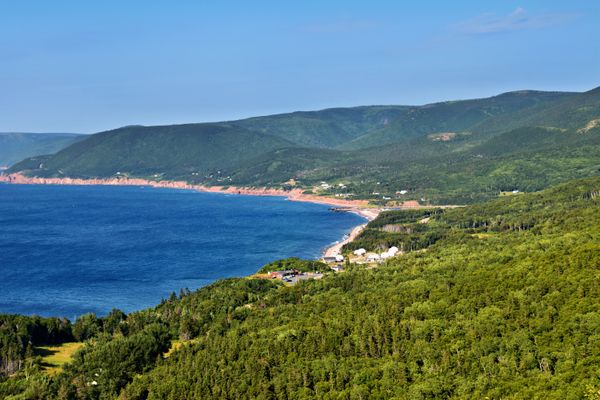
The Cabot Trail Itself
The full loop is 298 km and can be done in one day, but slowly — there's too much to see to rush it. Here are the key sections to know:
The Highlands Section (The Reason You're Here)
French Mountain (455m), MacKenzie Mountain, and North Mountain are the headline acts. The road climbs steeply, opens to panoramic ocean views, then drops back toward the coast through tight switchbacks. This is the section you came for — ride it at a pace that lets you actually look around.
Cheticamp
The western gateway to the park. Good place to fuel up before entering the national park — not all stations inside the park have premium fuel (91 octane). The Pursuit is happy on regular but top up here anyway.
Ingonish
Eastern side of the park — another fuel stop and a good lunch pull. The beach here is worth a short walk if the weather cooperates.
The Englishtown Ferry
You'll hit a decision point at Englishtown. The ferry cuts about 20 minutes off the route but skips some good riding. In June with decent weather and no time pressure, skip the ferry and ride the long way around. The ferry is free if you do end up using it — but save it for if you're behind schedule or weather turns.
Parks Canada Pass
You need one. If you stop your bike inside Cape Breton Highlands National Park — even just for a photo — Parks Canada staff in trucks will check. They're not shy about it. Pick up a day pass in Cheticamp or Ingonish. Around $10 CAD and saves you a real headache.
Fuel and Range on the Pursuit
The Pursuit with the PowerPlus 108 runs about 6.0–6.7 L/100km in real-world touring conditions. Two-up adds a bit to that figure — figure 6.5–7.0 L/100km loaded. With a 22.7L tank, that gives us somewhere around 300–340 km of comfortable range.
The trail loop is 298 km. I'll top up in Cheticamp before entering the park — there's no reason to stress fuel when the solution is a two-minute stop at a gas station you're passing through anyway. Fuel stops inside the park: Ingonish and Dingwall. Neither is guaranteed to have 91 octane, so Cheticamp is the move.
Gear and Prep Checklist
Rider and Passenger
- Helmets (DOT/ECE rated — full face or 3/4 minimum)
- Armoured riding jacket — bring a layer, June mornings on the highlands can be cold
- Riding gloves — proper ones, not summer half-gloves on mountain roads
- Over-pants or riding pants with knee and hip armour
- Waterproof layer — Cape Breton weather is genuinely unpredictable in June
- Bluetooth intercom charged and paired before leaving
Bike Prep
- Tire pressure check — cold, before leaving. Two-up weight shifts the optimal PSI slightly
- Brake check — pads and fluid
- Chain/belt inspection
- Lights all working
- Full tank leaving Dieppe — aim to hit Baddeck without stopping if possible
- Saddle bags packed and balanced — uneven weight affects handling
The Practical Stuff
- Parks Canada day pass (pick up in Cheticamp)
- Cash — some small stops on the trail are cash only
- Paper or offline map — cell service is spotty inside the park
- First aid kit
- Rain gear accessible — not buried in the bottom of a bag
- Snacks and water for the passenger especially
Drone Footage Plan — Hover Air Pro & DJI Mini 3
This trip I'm bringing two drones: the Hover Air Pro for establishing and follow shots, and the DJI Mini 3 for longer-range aerial footage. Both stay under 250g which keeps things simple from a registration standpoint — no RPAS Advanced certification required for most of what we're doing.
The Hover Air Pro is a selfie drone, so the plan is mostly establishing shots — getting the bike in frame with the highlands or coastline behind it, that kind of thing. It's compact enough to pull out quickly at a stop and get something usable without a full setup. The DJI Mini 3 handles the more deliberate wide-angle work where I want proper coverage of the landscape.
The Cabot Trail runs through Cape Breton Highlands National Park, which is Parks Canada managed — drones are not permitted inside the park boundaries without a permit. So the strategy is to identify good launch spots just outside the park perimeter where the scenery is still strong.
Planned Launch Spots (Outside Park Boundaries)
- Cheticamp — the town itself sits just before the park's western entrance. From the waterfront or the hillside above town you get a clear view of the highlands rising behind you. Strong establishing shot territory before entering the park.
- Ingonish area — the eastern park boundary is near Ingonish Beach. The beach and surrounding headlands are worth scouting for a post-park launch spot on the way back around.
- Pleasant Bay pulloffs — there are roadside stops just outside the park near Pleasant Bay that give you elevation and ocean views. Worth checking boundary maps before committing.
A note on the Cheticamp shots specifically: the mountains visible from town before you enter the park are genuinely dramatic — you get the highlands silhouette with the Gulf of St. Lawrence in the foreground. That's the establishing shot I'm most focused on capturing. We'll stop there anyway to pick up the Parks Canada day pass, so the drone stop fits naturally into the route.
I'll be checking the exact park boundary on the NatParks app before we leave. Cell service inside the park is unreliable, so having the boundary downloaded offline is worth doing ahead of time.
Home Base: Cabot Trail Motel, Baddeck
We're staying at the Cabot Trail Motel in Baddeck for the two nights — confirmed booking, June 12–14, CAD $395.46. Baddeck is the ideal town to base yourself for the trail. It sits right on the Bras d'Or Lake (a UNESCO Biosphere Reserve), has a main street with restaurants and pubs, and it puts you about 10 minutes from the trail's eastern entry point.
The Cabot Trail Motel itself overlooks the lake, has a heated outdoor pool, and reviews consistently praise the staff and the view. After a full day on the trail, overlooking the Bras d'Or is exactly the kind of thing that makes the trip feel like a proper adventure rather than just a long ride.
June Weather: What to Expect
June is peak season on the trail — the roads are clear, the greenery is in full bloom, and the weather is generally cooperative. That said, Cape Breton weather is Cape Breton weather. The highlands section especially can run significantly cooler than Baddeck — when you're climbing to 455 metres and dropping back to sea level multiple times, you'll feel real temperature swings.
- Average daytime temp in June: 18–22°C at sea level, 10–15°C at highland elevations
- Rain probability: Moderate — June is Atlantic Canada, so pack rain gear regardless of the forecast
- Wind: The exposed sections near the ocean and on the highlands can be gusty. Two-up adds sail area — be ready for crosswinds on the mountain sections
- Morning vs afternoon: Mornings tend to be clearer. Fog and cloud can roll in through the afternoon. If the forecast looks marginal, start early
Gear I'm Bringing on This Trip
📷 Cameras
- Insta360 X5 — 360 cam for scenic trail footage | Amazon.com
- Insta360 Ace Pro 2 — helmet POV on the mountain passes | Amazon.com
🚁 Drones
- HoverAir X1 — selfie drone for quick establishing shots | Amazon.com
- DJI Mini 3 — sub-250g, longer-range aerial landscape coverage | Amazon.com
🏍️ Bike & Riding Gear
Affiliate disclosure: Links above use my Amazon Associates tag. I earn a small commission at no extra cost to you.